October 14th Update 4:30 pm
The Outer Banks is open and greeting guests! The last area to open to visitors will be Hatteras Village, which will be accessible on Saturday morning, the 15th of October, starting at 7 am. Please note that there are areas of North Carolina which are still experiencing flooding and road closures. Please stay tuned to Department of Transportation resources and note areas on your route where there may be detours. Allow more time for travel and drive safely; we'll see you at the beach!
October 13th Update 10:30 am
The Dare County Control Group met Thursday morning and has established the following entry guidelines for the southernmost villages of Hatteras Island:
- Frisco – Visitors will be allowed access to the village of Frisco beginning 7 a.m. on Friday, October 14, 2016.
- Hatteras Village – Visitors will be allowed access to Hatteras Village beginning 7 a.m. on Saturday, October 15, 2016.
Visitors were allowed access to the Villages of Rodanthe, Waves, Salvo, Avon and most areas of Buxton beginning 7:00 this morning.
It is important for our visitors to check with their rental office to confirm reservations before traveling to the area since some properties were impacted and require repairs. Also, please be mindful that many residents and businesses of the island have suffered significant impacts and are in the process of recovering so your patience and understanding is truly appreciated.
If you'd like to help, residents of Frisco and Hatteras Village are in need of plastic totes to store belongings while they clean up damaged properties. You may drop off totes at one of the Sun Realty offices if you'd like, and we will deliver them where they are needed. You can also make monetary donations to the Cape Hatteras United Methodist Men, a community-wide organization that helps families on Hatteras Island with emergency assistance. Donations can be made to Cape Hatteras United Methodist Men, PO Box 1591, Buxton, NC 27920. 100% of donations are used for emergency relief.
October 12th Update 4:30 pm
Visitors will be allowed access to the Villages of Rodanthe, Waves, Salvo, Avon and Buxton beginning 7 a.m. on Thursday, October 13, 2016. Restrictions remain in place for areas south of Buxton Back Road and NC 12 (NC SR 1232 at Cape Hatteras Secondary School), including the villages of Frisco and Hatteras Village. Residents, non-resident property owners and non-resident employees of businesses with proper reentry passes will be allowed access. Local officials will meet again on Thursday morning to review recovery efforts to determine if a time frame can be established for visitors to enter the southernmost villages. Any updates will be announced as quickly as possible. Sign up to receive email notifications at www.darecountyem.com.
October 11th Update 9:40 am
There are now no restrictions for access onto the northern beaches of Dare and Currituck Counties. Restrictions continue on Hatteras Island due to sand and debris on the road. Please read the full Dare Emergency Incident Information Update for complete details.
For our guests expecting to check-in for this week, please exercise patience, as we are still in the process of checking homes for damages and getting things cleaned and ready for you. Some of our homes were inaccessible over the past few days, so we were unable to get to them and prepare them for your arrival. We are working hard to have all homes ready for guests as soon as possible. Please call your check-in office for status and again, we ask for patience as we continue prepping homes.
Access to Hatteras Island is still restricted to homeowners, residents, and essential personnel at this time.
October 10th Update 1:30 pm
Non-Resident Property Owners will be permitted entry to areas north of Oregon Inlet effective 2:00 p.m. today. This includes the Towns of Duck, Southern Shores, Kitty Hawk, Kill Devil Hills, Colington, Nags Head, Roanoke Island and mainland Dare County. Non-Resident Property Owners must show the “North of Oregon Inlet” reentry permit that was mailed to them by Emergency Management or have a current Dare County property tax receipt, which can be obtained online at the Dare County website www.darenc.com.
Non-resident employees of businesses will be allowed entry with a reentry pass. For information regarding re-entry passes and procedures for Dare County, visit www.darenc.com/reentry.
HATTERAS ISLAND – ACCESS INFORMATION
Restrictions for access to Hatteras Island remain in place. At this time, access is permitted only for the following:
- Priority One – Essential Personnel – (Utilities, Government, Medical Personnel)
- Priority Two – Permanent Residents & Essential Personnel for Critical Businesses
Hatteras Island Non-Resident Property Owners and Non-Resident Employees of Businesses will be allowed access to Hatteras Island effective 7:00 a.m., Tuesday, October 11 with proper identification. Non-Resident Property Owners will need to show their “South of Oregon Inlet” reentry permit or have a current Dare County property tax receipt. Non-resident employees of businesses will be allowed entry with a reentry pass.
Important Safety Notice For Those Accessing Hatteras Island – Use extreme caution traveling between the Bonner Bridge and Rodanthe due to large amounts of sand and water on NC Highway 12. NCDOT is working to address the situation. Until conditions improve, travel in this area should only be attempted in high profile 4-wheel drive vehicles.
We realize visitors are anxiously waiting to receive notice to enter Dare County. It is important for Dare County Emergency Management and local officials to ensure that infrastructure and services are in place to properly accommodate guests. Updates regarding visitor reentry will be announced as soon as a determination is made. No announcements are expected before Tuesday afternoon.
October 10th Update 12:25 pm
Sun Realty offices opened at 10:30 this morning. We are currently out assessing properties for storm related damages, power outages and accessibility. Entry to the Dare and Currituck Outer Banks is still restricted to essential personnel and permanent residents. Town and County officials are also out checking the condition of roads and utilities. Water is receding but there are still many areas and roads that are either flooded and inaccessible or only accessible with a high-profile 4x4 vehicle. Dominion Power is working hard to restore power but there are still many outages.
We will continue to communicate with incoming guests as updates are made available. We ask for your patience and understanding as the Outer Banks works to recover from this storm. We hope to welcome you soon.
October 9th Update 12:15 pm
Here is the latest from the Dare County Control Group:
Access is Restricted to Dare County and All Motorists Are Urged To Stay Off Roads
Due to greater impacts than anticipated from the storm, access to Dare County is restricted. By order of the Dare County Control Group, entry to Dare County for all areas of Dare County and for Currituck County’s Outer Banks will be permitted only for the following:
- Priority One – Essential Personnel
- Including essential utilities personnel, government personnel, medical personnel, and damage assessment personnel.
- Priority Two – Permanent Residents & Essential Personnel for Critical Businesses
- Permanent Residents of Dare County and Currituck County’s Outer Banks will be allowed reentry with a valid NC driver’s license with a local address or a current County property tax receipt. Non-resident essential personnel of critical businesses will be permitted reentry only with a permit.
Although flood waters are beginning to subside, Dare County remains under a Tropical Storm Warning. Be aware that dangerous conditions continue to exist, including downed trees and power lines, standing flood waters and tropical storm force winds. Everyone in Dare County should stay off roads and avoid travel. If you have moved your vehicle to higher ground, please let it remain there until the winds subside.
When conditions permit, personnel from Dare County and the Towns will assess the damage. Downed trees and power lines have been reported throughout the county and there are widespread power outages. Power companies are working to restore service as soon as possible. To report outages:
- Dominion North Carolina Power 1-866-DOM-HELP (1-866-366-4357) or Dom.com
- Cape Hatteras Electric Cooperative 1-866-511-9862
- Tideland Electric 1-800-637-1079 or 252-943-3046
For updated information regarding the status of all roads and bridges in Dare County and across North Carolina, visit tims.ncdot.gov/tims or call 877-368-4968. For the most up to date information regarding the status of NC12, visit www.facebook.com/NCDOTNC12.
Residents and visitors can contact Dare County Emergency Management by calling 252.475.5655 or visiting www.darenc.com for updated information. The next Bulletin will be issued as needed but no later than 7 p.m. Sunday.
October 9th Update 11:45 am
All Sun Realty offices are closed today. Sunday's check-ins have been suspended and will be moved to Monday, as soon as all damages have been assessed. We apologize for any inconvenience, and appreciate your patience as we work through the effects of this storm. Stay safe and off the roads until flood waters have receded.
October 9th Update 9:00 am
Due to the unexpected track and intensity of Post-Tropical Storm Matthew, all Sun Realty offices are closed until the weather and road conditions allow for safe travel. We hope to open later today but that depends on when the storm passes.
Matthew brought wind, rain and ocean overwash to the Outer Banks. We are still experiencing the effects of this powerful storm. Officials are urging everyone to avoid any unnecessary travel. There are numerous road closures due to flooding. Please check conditions.
We are extending a courtesy, complimentary late departure for all guests scheduled to depart today. Please don't get out on the road until conditions improve. If you plan on arriving today we hope to be at the office to welcome you this afternoon. If we are unable to greet you, we will leave your check-in envelope in the After Hours box outside the rental office door. If you choose to delay your arrival we will be open at 8:30 Monday morning and you can pick up your keys at any time.
Please travel safely!
October 7th Update 3:00 pm
Below is the 1 pm update from the Dare County Sheriff's Office. We urge our guests to use their best judgment when making travel plans. There are no evacuation orders in place for Dare or Currituck Counties at this time, and we anticipate being open for regular business hours both Saturday and Sunday, but we encourage all guests to pay close attention to DOT updates and be safe while driving.
"Dare County is now under a Tropical Storm Warning. According to the National Weather Service, the combination of abnormally high coastal water levels, storm surge, and extremely heavy rainfall is expected to cause a dangerous and life threatening flooding event for the Outer Banks. The National Weather Service has indicated that we should expect ocean overwash in vulnerable areas. We should also expect soundside flooding of up to 4 feet above ground in areas prone to flooding, primarily on Hatteras Island. The National Weather Service is highly discouraging travel across northeastern North Carolina this weekend. As conditions deteriorate, road closures and travel restrictions are anticipated in Dare County, particularly for portions of Highway 12 on Hatteras Island.
Because of dangerous travel conditions, visitors throughout Dare County are encouraged to depart today (Friday) and travel to the area should be postponed until conditions improve. For information regarding road conditions and closures, visit tims.ncdot.gov/tims. For the most up to date information regarding the status of NC12, visit www.facebook.com/NCDOTNC12."
October 7th Update 11:30 am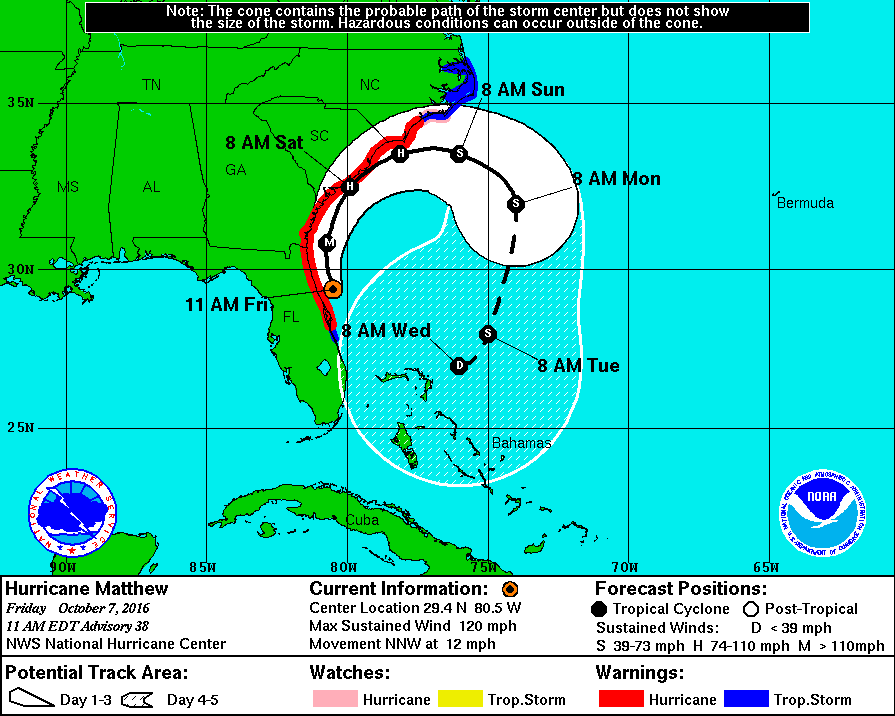
Hurricane Matthew is still a major category 3 hurricane and is sliding along the eastern Florida coast. The forecast track continues to show an easterly turn before the storm reaches the southern NC coast, and then a southernly turn back toward the Bahamas. There is a Tropical Storm Warning in effect at this time from north of Surf City to Duck, as well as the Pamlico and Albemarle Sounds. Continue to monitor local emergency management sources and the NC Department of Transportation, NCReady.org for any trvel advisories that may be issued. At this time, there are NO evacuations or bridge closings issued. Travel safely!
October 5th Update 5:00 pm
The track of Hurricane Matthew continues to pull away from the Outer Banks. The storm track now shows a southern turn, after the east turn it is expected to take over the weekend. Matthew is a category 3 hurricane, with maximum sustained winds of 120 mph. Our thoughts are with our neighbors to the south in Florida, as they prepare for Matthew to come very close to shore sometime tomorrow night.
October 5th Update 2:15 pm
Conditions continue to be favorable that Hurricane Matthew will make a turn toward the east, keeping it well off the NC coast, and away from the Outer Banks. Things can change as the storm approaches, so we continue to stay vigilant in our preparations. The following was released from Dare County Emergency Management at 1 pm today:
"The Dare County Control Group met again this morning to review Hurricane Matthew. The current forecast from the National Hurricane Center shows the storm tracking further south than previously predicted and away from Dare County. While this is an improved forecast for our area, it is too early to know for sure that this latest track will continue to hold its course.
Because of the uncertainty of the forecast, residents and visitors are urged to remain vigilant and continue to closely monitor the storm because even moderate changes in the projected path could lead to significant impacts for Dare County. The state of emergency declaration will remain in place in case conditions change and protective measures become necessary.
Dare County is already experiencing dangerous rip currents and rough surf conditions that are expected to continue. Dare County Emergency Management strongly urges everyone to stay out of the ocean.
Dare County Public Works is operating on a regular trash collection schedule. Because of the winds that are anticipated in the coming days, residents are asked to roll up and secure their garbage cans as quickly as possible after pickup to reduce the risk of injury and property damage.
To receive email updates directly from Dare County Emergency Management, register online at www.darecountyem.com and follow @DareCountyEM on Twitter.
Residents and visitors may contact Dare County Emergency Management by calling 252.475.5655 or visiting www.darenc.com for updated information."
October 5th Update 11:55 am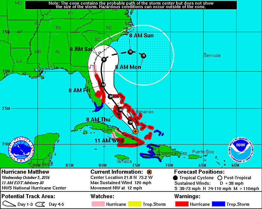
We're cautiously optimistic, as each National Hurricane Center update that has come out today, at 5:00, 8:00, and 11:00 am, has been more favorable for the Outer Banks. The track of Hurricane Matthew has shifted direction, showing a northeast-east route well before reaching the southern NC coast. As we await an update from the Dare County Control Group, promised by 2:30 pm today, we continue to prepare for any changes in this track. Ocracoke Island is under evacuation orders for visitors, beginning this morning, and Hyde Country officials have ordered residents to evacuate starting Thursday morning. But so far, no evacuation orders have been issued for Hatteras Island, north to Carova. Continue to watch all weather updates by the National Hurricane Center and stay tuned to this page for any additional information regarding storm preparedness and any changes to travel routes.
October 4th Update 4:40 pm
Hurricane Matthew continues to bring uncertainty to the Outer Banks forecast. While the track of the storm remains unclear, tropical storm or hurricane conditions could impact the North Carolina coast later this week or this weekend. Currently, there are no hurricane warnings, watches or travel advisories for Dare or Currituck Counties. Emergency Management is closely monitoring the track of Hurricane Matthew and is asking residents and visitors to keep a close eye on the storm as it moves from the Caribbean towards the Atlantic over the next few days.
We are monitoring all sources of information and will do our best to keep you informed by email. Please check the links provided for updates on Hurricane Matthew as well our Facebook and Twitter accounts.